Zim, Minnesota
Zim | |
|---|---|
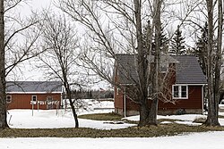
 The Zim Post Office | |
| Coordinates: 47°18′25″N 92°36′12″W / 47.30694°N 92.60333°W | |
| Country | United States |
| State | Minnesota |
| County | Saint Louis |
| Township | McDavitt Township |
| Elevation | 1,335 ft (407 m) |
| Population | |
• Total | 20 |
| Time zone | UTC-6 (Central (CST)) |
| • Summer (DST) | UTC-5 (CDT) |
| ZIP code | 55738 |
| Area code | 218 |
| GNIS feature ID | 662843[1] |
Zim is an unincorporated place in McDavitt Township, St. Louis County, Minnesota, United States.[1]
Geography
[edit]The community is located 14 miles southwest of the city of Eveleth at the junction of Saint Louis County Highway 7 and County Road 27. The Saint Louis River is nearby.
History
[edit]
A post office called Zim was established in 1899, and remained in operation until 1990.[2] The community derives its name from a logging camp run by a lumberman named Zimmerman who worked in the area.[3]
Arts and culture
[edit]The nearby Sax–Zim Bog area is home to one of the world's best birdwatching places and the site of the annual Sax–Zim Winter Birding Festival held in February.[4] The bog was named for Zim and the nearby community of Sax.[4]
Zim is home to noted rock music transcriber Jordan Baker, who has authored songbooks for Dream Theater, Steve Vai and Metallica.
References
[edit]- ^ a b c U.S. Geological Survey Geographic Names Information System: Zim, Minnesota
- ^ "St. Louis County". Jim Forte Postal History. Retrieved August 7, 2015.
- ^ Upham, Warren (1920). Minnesota Geographic Names: Their Origin and Historic Significance. Minnesota Historical Society. p. 492.
- ^ a b Gustav Axelson (January 18, 2013). "In a Minnesota Bog, a Festival of Birds". The New York Times. Retrieved June 4, 2016.
- Rand McNally Road Atlas – 2007 edition – Minnesota entry
- Official State of Minnesota Highway Map – 2011/2012 edition


