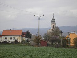
Rudník, Košice-okolie District
Appearance
Rudník
Rudnok | |
|---|---|
 | |
Location of Rudník in the Košice Region Location of Rudník in Slovakia | |
| Coordinates: 48°41′N 21°01′E / 48.69°N 21.01°E | |
| Country | |
| Region | |
| District | Košice-okolie District |
| First mentioned | 1255 |
| Area | |
• Total | 22.98 km2 (8.87 sq mi) |
| Elevation | 314 m (1,030 ft) |
| Population (2021)[3] | |
• Total | 623 |
| Time zone | UTC+1 (CET) |
| • Summer (DST) | UTC+2 (CEST) |
| Postal code | 442 2[2] |
| Area code | +421 55[2] |
| Car plate | KS |
| Website | www |
Rudník (Hungarian: Rudnok) is a village and municipality in Košice-okolie District in the Košice Region of eastern Slovakia.
Culture
[edit]The village has a general store. In the village is the historic church of St. Juraja (St. George) and the House of Culture (social gathering hall). Three kilometers above the village is the church of St. Anne.
Transport
[edit]There is a bus line from Košice to the village.
References
[edit]- ^ "Hustota obyvateľstva - obce [om7014rr_ukaz: Rozloha (Štvorcový meter)]". www.statistics.sk (in Slovak). Statistical Office of the Slovak Republic. 2022-03-31. Retrieved 2022-03-31.
- ^ a b c "Základná charakteristika". www.statistics.sk (in Slovak). Statistical Office of the Slovak Republic. 2015-04-17. Retrieved 2022-03-31.
- ^ "Počet obyvateľov podľa pohlavia - obce (ročne)". www.statistics.sk (in Slovak). Statistical Office of the Slovak Republic. 2022-03-31. Retrieved 2022-03-31.
External links
[edit]


