
Jonsvatnet
| Jonsvatnet | |
|---|---|
 Interactive map of the lake | |
| Location | Trondheim Municipality, Trøndelag |
| Coordinates | 63°21′56″N 10°34′55″E / 63.3655°N 10.5820°E |
| Primary outflows | Vikelva |
| Basin countries | Norway |
| Max. length | 8 kilometres (5.0 mi) |
| Max. width | 4.5 kilometres (2.8 mi) |
| Surface area | 14.26 km2 (5.51 sq mi) |
| Shore length1 | 43.64 kilometres (27.12 mi) |
| Surface elevation | 148 metres (486 ft) |
| References | NVE[1] |
| 1 Shore length is not a well-defined measure. | |
Jonsvatnet[2] is a lake in Trøndelag county, Norway. Most of the lake is in the eastern part of Trondheim Municipality, with a very small part of the shoreline belonging to Malvik Municipality. The lake is the main source for drinking water for the city of Trondheim.[3]
Media gallery
[edit]-
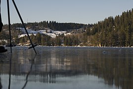
 View of the frozen lake in winter
 -
 View of the lake (Feb 2009)
 -
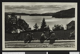 Summer at the lake (c. 1915)
 -
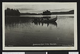 Summer at the lake (c. 1915)


See also
[edit]References
[edit]- ^ "Innsjødatabase". NVE.no (in Norwegian). Retrieved 2025-02-06.
- ^ "Informasjon om stadnamn". Norgeskart (in Norwegian). Kartverket. Retrieved 2025-02-06.
- ^ Rosvold, Knut A., ed. (2024-11-26). "Jonsvatnet". Store norske leksikon (in Norwegian). Foreningen Store norske leksikon. Retrieved 2025-02-06.