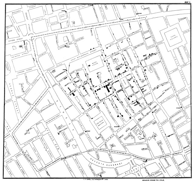
File:Snow-cholera-map-1.jpg
Appearance

Size of this preview: 639 × 599 pixels. Other resolutions: 256 × 240 pixels | 512 × 480 pixels | 819 × 768 pixels | 1,092 × 1,024 pixels | 2,183 × 2,048 pixels | 20,124 × 18,877 pixels.
Original file (20,124 × 18,877 pixels, file size: 18.38 MB, MIME type: image/jpeg)
| This is a featured picture, which means that members of the community have identified it as one of the finest images on the English Wikipedia, adding significantly to its accompanying article. If you have a different image of similar quality, be sure to upload it using the proper free license tag, add it to a relevant article, and nominate it. |
| This image was selected as picture of the day on the English Wikipedia for January 22, 2024. |
File history
Click on a date/time to view the file as it appeared at that time.
| Date/Time | Thumbnail | Dimensions | User | Comment | |
|---|---|---|---|---|---|
| current | 21:19, 16 November 2020 |  | 20,124 × 18,877 (18.38 MB) | Artoria2e5 | Reverted to version as of 14:12, 6 May 2020 (UTC) |
| 21:12, 16 November 2020 |  | 1,092 × 1,024 (320 KB) | Artoria2e5 | temporarily reduce size for wikimaps | |
| 14:12, 6 May 2020 |  | 20,124 × 18,877 (18.38 MB) | Sette-quattro | higher resolution version | |
| 13:53, 22 June 2007 |  | 3,045 × 2,840 (1.13 MB) | Finavon | {{Information |Description=Original map made by John Snow in 1854, copied from http://matrix.msu.edu/~johnsnow/images/online_companion/chapter_images/fig12-5.jpg Author died in 1858, material is public domain. |Source=Originally from [http://en.wikipedi |
File usage
More than 100 pages use this file. The following list shows the first 100 pages that use this file only. A full list is available.
- 1846–1860 cholera pandemic
- 1854 Broad Street cholera outbreak
- Charles Cheffins
- Dot distribution map
- GIS and public health
- Health geography
- History of water filters
- History of water supply and sanitation
- Human geography
- John Snow
- Natural experiment
- Public health
- Slow sand filter
- Statistical graphics
- Thematic map
- Water purification
- Talk:1854 Broad Street cholera outbreak
- User:Aetarrell/Practice
- User:Life in General/Userboxes/HumanGeography
- User:Nvvchar/Archives/September 2016 - present
- User:Wouterstomp/test
- User:Zana.percy/sandbox
- User talk:7&6=thirteen/Archive 14
- User talk:Amkgp/Archive 5
- User talk:Another Believer/Archive 31
- User talk:Awkwafaba/Archive 4
- User talk:BabbaQ/Archive 10
- User talk:Bananasoldier/Archive 8
- User talk:Becky Sayles/Archive 15
- User talk:CAPTAIN RAJU/Archive 88
- User talk:CanadianDude1/Archives/ 2020/May
- User talk:Casliber/Archive 65
- User talk:ChamithN/Archive 32
- User talk:Class455/Archive 21
- User talk:Clovermoss/Archive 5
- User talk:CyberXRef/Archive 10
- User talk:CycloneYoris/Archive 9
- User talk:DannyS712/Archive 12
- User talk:Davey2010/Archive 2020 1
- User talk:Esquivalience/Archive 15
- User talk:EuroCarGT/Archives/2020/May
- User talk:FULBERT/Archive 32
- User talk:Fanoflionking/Archive 1
- User talk:GiantSnowman/2020
- User talk:Gwooodward
- User talk:HectorAE/Archive 6
- User talk:Hhkohh/Archive 5
- User talk:Isochrone/Archives/2020/May
- User talk:Jakesyl/Archives/2020/May
- User talk:Joshualouie711
- User talk:K6ka/Archive 26
- User talk:KGirlTrucker81/Signpost/Archive 16
- User talk:Khamar
- User talk:Kpgjhpjm/Archive 9
- User talk:LEvalyn/Archive 1
- User talk:MBlaze Lightning/Archive 23
- User talk:Mahensingha/Archive 53
- User talk:Marek69/Archive 46
- User talk:Masssly/Archive/May 2020
- User talk:Mathwhiz 29
- User talk:Mitchellhobbs/Archives/1
- User talk:MoarSmtp
- User talk:MusikAnimal/Archive 42
- User talk:Northamerica1000/Archive 102
- User talk:NorthwestPassage/Archive 3
- User talk:OfficialNeon
- User talk:Path slopu/Archive 6
- User talk:Pratyya Ghosh/Archives/93 (2020-05)
- User talk:Quenhitran/Archive 55
- User talk:Qwertyxp2000/Archives/2020/May
- User talk:Rsrikanth05/Archive May 2020
- User talk:SS49/Archive 16
- User talk:Sahara4u/Archive 5
- User talk:Sam Sailor/Archive 24
- User talk:Sanskari/Archive 108
- User talk:Sarason
- User talk:Silver seren/Archive 24
- User talk:Smileguy91
- User talk:Spurb/Archive 13
- User talk:StudiesWorld/Archive 34
- User talk:Susmuffin/Archive 1
- User talk:Theopolisme/Archive 30
- User talk:Topcipher/Archives/2020/May
- User talk:TruthToBeSpoken/Archive 5
- User talk:Tyrone Madera
- User talk:Valereee/Archive 24
- User talk:Vanilla Wizard/Archive 1
- User talk:Vaulter/Archive 15
- User talk:VictorTorres2002/Archive 2
- User talk:Whiteghost.ink/2020 Archive
- User talk:Winner 42/Archive 24
- User talk:Zanygenius2 (WV-en)/Archive 1
- Wikipedia:Featured picture candidates/October-2021
- Wikipedia:Featured picture candidates/Snow cholera map
- Wikipedia:Featured pictures/Diagrams, drawings, and maps/Maps
- Wikipedia:Reference desk/Archives/Humanities/2010 August 24
- Wikipedia:WikiProject Medicine/Recognized content
- Wikipedia talk:Articles for improvement/Archive 23
- Portal:Geography/Intro/6
- Portal:Geography/Intro/Image
View more links to this file.
Global file usage
The following other wikis use this file:
- Usage on ar.wikipedia.org
- Usage on bg.wikipedia.org
- Usage on bh.wikipedia.org
- Usage on bn.wikipedia.org
- Usage on ca.wikipedia.org
- Usage on de.wikipedia.org
- Usage on de.wikiversity.org
- Usage on en.wikibooks.org
- Usage on en.wikiversity.org
- Usage on es.wikipedia.org
- Usage on et.wikipedia.org
- Usage on eu.wikipedia.org
- Usage on fi.wikipedia.org
- Usage on fr.wikipedia.org
- Usage on gl.wikipedia.org
- Usage on ha.wikipedia.org
- Usage on he.wikipedia.org
- Usage on hr.wikipedia.org
- Usage on hy.wikipedia.org
View more global usage of this file.

